In the morning we noticed that the area around our picnic table was a city for voles, having been cleared and flattened for official use. Just off the concrete slab, one of the industrious creatures, unable to wait any longer for the intruders to leave her in peace, was popping out of her hole for an armload of fresh ground cover, then popping right back in. The instantaneity of this backward motion seemed a bit overdramatic, until I remembered the hawk’s vigil from the night before.
We slept in till around nine – a response to the fresh air and exercise, I suppose. There was a surprising amount of traffic on this dirt offshoot, for a midweek summer day. One pickup seemed to go by every hour or so with a row of riders on the tailgate. More folks living at the top of the stream than we might have expected.
For a moment we thought we might need to ask the Fish & Game guys for another favor: having left the SUV unstarted for two nights, we’d evidently drained the battery with the various openings and closings of the power hatch and high-tech door. But it turned out we could get one weak jolt out of the second battery, meant to run the trailer appliances.
Time bomb
Sure enough, the road beyond Willow Creek was suddenly smooth and well maintained. However, the first couple miles of it wound through some of the worst burn areas we would see on the whole trip.

From the vantage of the intersection where a sideroad leads east toward Snow Lake, all of the nearby woods, formerly large pines in dense formation, appeared as blackened poles, with no hope of regeneration. And, beyond these denuded hills, back across the ridges we had driven in on, was more of the same except on an Olympic scale.
For a century, we suppressed wildfires in the name of a few property owners, an extractive timber industry and a short-sighted notion about preserving beauty. We mostly got away with it until the effects of climate change kicked into full gear over the last generation.
It turns out that we were only loading the bomb bay for a moment of reckoning when this vast fuel source would consume itself so thoroughly that it’s finally of marginal use to anybody, not to mention the stunning blow to the whole purpose of designating wilderness.
Money shot
Snow Lake sits at the bottom of the gentle valley that gives birth to the river’s Middle Fork, and so has a certain claim to the title of Headwaters of the Gila. The campground there was indeed open, and its two separate loops – one overlooking the lake, the other wandering among the pines – gave us our pick of perspectives.
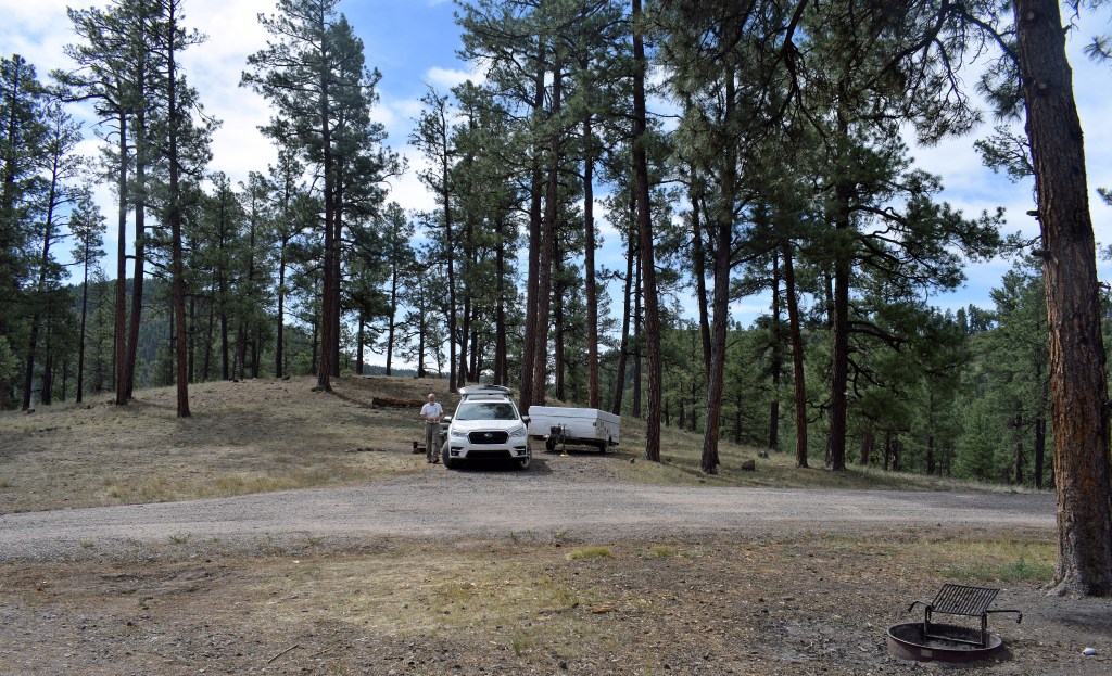
We chose the top spot, at the end of the road. (After 2 nights without, we would have campground toilets and fresh water.) It was already hot, around 90, but it was still early, so we suited up for a hike.
The topo told us that, as with the day before, the mesa above us separated us from a major creek. If we could get over and down to it, we could follow the path leading around to the confluence with the Middle Fork and back over the dam to the campgrounds.
The facility sits at the border with the Wilderness, so we had to sidle past a gate to get onto the faint trail along the crest of a narrow buttress leading straight to the low point of the ridge off to the southwest. This might have been the gentle way, but it also was the longest, and we were flushed and winded as we came into the clear among the sparse pines at the crest.
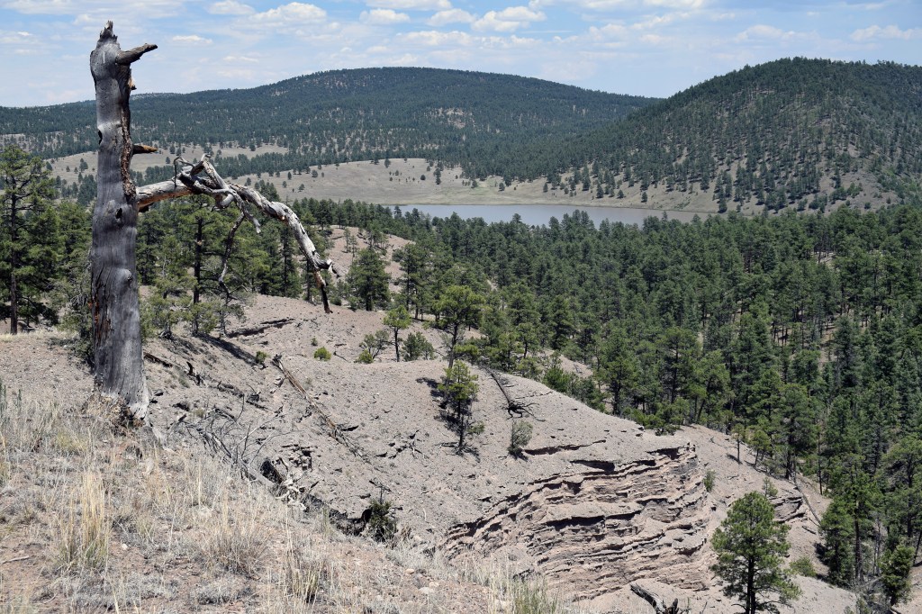
From here, we had an unimpeded view of western half of the Wilderness. Out of sight below, Gilita Creek ran through a deep groove, beyond which was the forested carpet of Iron Creek Mesa, where we had been wandering the day before. Beyond that were the stately lines of the Jerky Mountains, which obscured the drainages of the West Fork. More to the east we could look as through a gunsight down the passageway of the Middle Fork, where a thick haze swallowed the farthest ridges.
What the hawk saw
A skybox view of this glory, from our seat on a fallen tree trunk, came with a hiker’s light lunch and a strategy session. For the second time, I was drawn to the idea of hanging onto our hard-earned elevation, making the most of the long perspective. If we followed the faint jeep track along the ridge, we could always watch for a way down to the stream.
Long after the track disappeared, though, we were still enjoying the vistas on both sides – the rugged mountains to the south, the rolling grasslands to the north – and I lobbied for a visit to the tip of the mesa and a view of the dam.
Finally, a rock jumble offered the aficionado’s view of the lower lake. I couldn’t resist belting out an Alpine yodel, coercing the attention of the couple, distant even through the binoculars, who were pacing the length of the earthen dam below. Just a ways further, another outcropping opened up to a southern view, including perhaps a mile stretch of the incipient river before it plunges through a narrow bottleneck and out of sight.
The way back
In search of a way down to Gilita Creek, we angled over to where a wide glen drained off the edge of the mesa – slowly, so as not to disturb the tranquility of a white-tail doe and her fawn, who was about her own size. As we made a wide circle around them, she appeared unconcerned, most of the time resting in grassy patches of shade. The fawn, though, stayed on its feet, its eyes locked on us, ears perked.
The topo warned us that the slope down to the creek was steep, quickly losing about 400 feet, and it was good to its word. In fact, any descent from the rim was blocked by a wall of deciduous shrubs of indeterminate depth. When we hiked the creek trail the next day, we could see that this hedge actually was a narrow band just below the rim, but below that was a steep slope of rubble that would have been a nightmare to traverse, either up or down.
We had seen that the descent to the campground from the far edge of the mesa was vastly more reasonable, so we continued our circle around the deer and made our way back to that gentler slope. It still took us about an hour to get back, but it was a bit like skiing, with long sweeps back and forth down among the occasional boulders and fallen trees. I don’t remember my pair of hiking poles ever coming in handier.
At some point, we re-crossed the Wilderness fence, then a series of gullies that drained the mesa. As I had expected, the last saddle, topped by the glint of the setting sun through the trees, opened up directly below our campsite. We had just enough daylight left to set up the trailer and convert the last of our fresh veggies into a hearty stir fry.
A light in the wilderness
Earlier in the day, a single guy scouting for a campsite asked me where the sun would be going down, hoping for evening shade. I was a bit off in my calculations, and we now saw him down there with his tent set up in full sun. I would later suspect, though, that he knew his directions better than I and really was just using that topic as an icebreaker.

As with so many people we’d already met, Jeff was visiting from Tucson. In fact, he came from farm family who still lived in Gadsden, only a few miles from us. His professional life had mostly been spent in Phoenix, though, for the state Department of Environmental Quality. I was sorry that, between weak laws and a good-old-boy system of non-enforcement, he seemed to have ended up with a feeling of uselessness about his life’s work, but his honesty about it gave me an immediate fondness for him.
It turned out that Jeff had systematically made contact with everyone in the campground that day. When two giant RV rigs came lumbering through, he found out that they were arriving so late because they, too, had used the high road off the highway, without a clue about what they were in for. I spent some effort on picturing that scene, no doubt enjoying it more than I should.
Jeff had already eaten (he’d pre-prepared a dozen meals before he left), but he came over around dusk for a chat. I had pegged him as a lightweight earlier when he said it was too hot to hike; in fact, he was a dedicated adventurer with a story for every occasion. On the subject of pop-up trailers, he’d had a harrowing experience with high winds on the Gulf of California – recounted with enviable narrative skill. He had hiked a three-day segment on the Inca Trail, which we had bypassed on trains on our trip to Peru, and he would have done the whole thing if his traveling companion had been athletically inclined.
He had a tragic personal story concerning Lyme Disease, too, one that explained why he had to get off into the outdoors by himself a couple of times a year. Indeed, I could have listened to this guy for days. I even imagined a few fanciful scenarios in which he was something other than he seemed – an agent of some kind, or maybe a saint, sharing parables that people could take back to use in their daily lives.
The source
When we got up at dawn, Jeff’s site was empty. We packed up, too, and parked the rig down by the lake so we’d be ready for the road when we were done with our hike.
On the way back to the dam, we got a closeup look at a blue heron, and we surprised a couple of guys in a boat by the shore. They didn’t seem to be catching much, but they were enjoying their attitude-adjustment-of-choice as much as they were the natural setting, from the smell of it.

The waterline on the rocks of the dam showed that the level of the lake was significantly low. On the other side, only a string of stagnant ponds showed where the stream sometimes flowed. It wasn’t until we came to Gilita Creek a quarter mile down that the river could boast any running water.
From there, a distinct trail led along the wide terrace beside the river – the same straight stretch I had seen from above the day before. We turned around at the rocky narrows, though, because it was Gilita Creek we really wanted to see.
The watcher
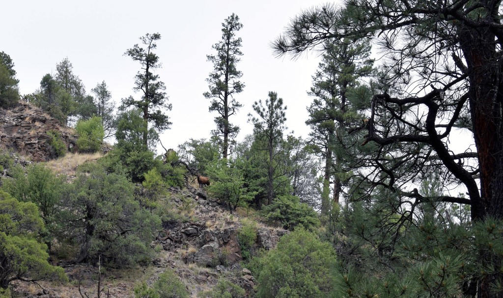
From the confluence, the trail up the Creek was faint, marked at intervals by pink ribbons tied to the trees. A short ways along, Lori somehow spotted an elk buck high above us on the slope – a place where we probably could have descended from the mesa the day before. He was motionless between a couple of junipers, regarding us with the same intense interest as we did him. He had no rack, but his body was massive – far out of proportion with his head, like some fantasy creature out of Japanese anime.
We found a deep spot in the stream to strip and submerge ourselves in quick, bracing bursts, finding amusement in picking out harrowing routes up the canyon wall and wondering where it was that we had looked down from.
After five days in the outdoors, time was pressing on us a bit, but we hiked on a ways to get a feel for the wild beauty of this ravine as it wound up to meet Willow Creek. What finally turned us around were some very interesting piles of scat that we speculated to be bear, filled with undigested berries and getting fresher as we went upstream.

A final overview
The graded road that zagged north toward Reserve was indeed a superhighway compared with what we had already traveled. Hoping to squeeze as much as possible out of our last day, we followed a side track that advertised an overlook from Negrita Mountain. To one side of the track was an impromptu RV site – seemingly a microcosm of America, complete with internal-combustion toys of various kinds and a veritable Old Glory collection. To be fair, it was coming up on the Fourth of July.
At a junction, the road was no longer passable with our rig, so we parked and pursued the panorama up the hill on foot. The watchtower at the top was an unexpected payoff in itself, but I couldn’t have hoped that there would be no chain or discouraging signs, or that the massive trap door at the top would be unlocked.
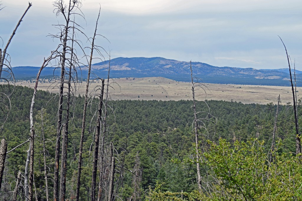
The 20’-by-20’ inside space was bare except for the capped end of a natural gas line, but in all four directions the view was breathtaking if not actually dizzying. A straight graded road across the pale grasslands led northeast out of the national park, toward Elk Mountain, with the singed ridges of Eagle Peak farther off to the north. On all other sides, wooded ranges stretched out of sight into the haze. Thankfully, no fires in sight.
Signs of the times
We still had several mountain passes ahead of us on the way out. At one point, we could look far down the valley where the San Francisco River finally dropped off into the collapsed mass of Gatlin Canyon. Soon, we were emerging into occupied territory, with ranches and pastureland filling the verdurous bottomland. In Reserve, not many people were out and about, though a few restaurants and bars were open behind their quaint Western storefronts.
We had accomplished our goals concerning the Gila Wilderness, and now we were just casting around for what to do with one more night at high elevation – Apache Creek to the northeast, perhaps, or Alpine to the west. We also had cell service for the first time in days, however, and a couple of catch-up phone calls convinced us that we needed to head for Tucson tonight to rejoin the real world.
U.S. 180 took us back past the Alma Trading Post, the (closed) Aldo Leopold Vista and the face of the Mogollon Mountains, bathed this time in the golden glow of sunset. However, Route 78 along Mule Creek was new to both of us. Just at sundown, we descended through the canyon where the creek falls out of the highlands to the desert floor, on its way to meet the Gila at Three Way.
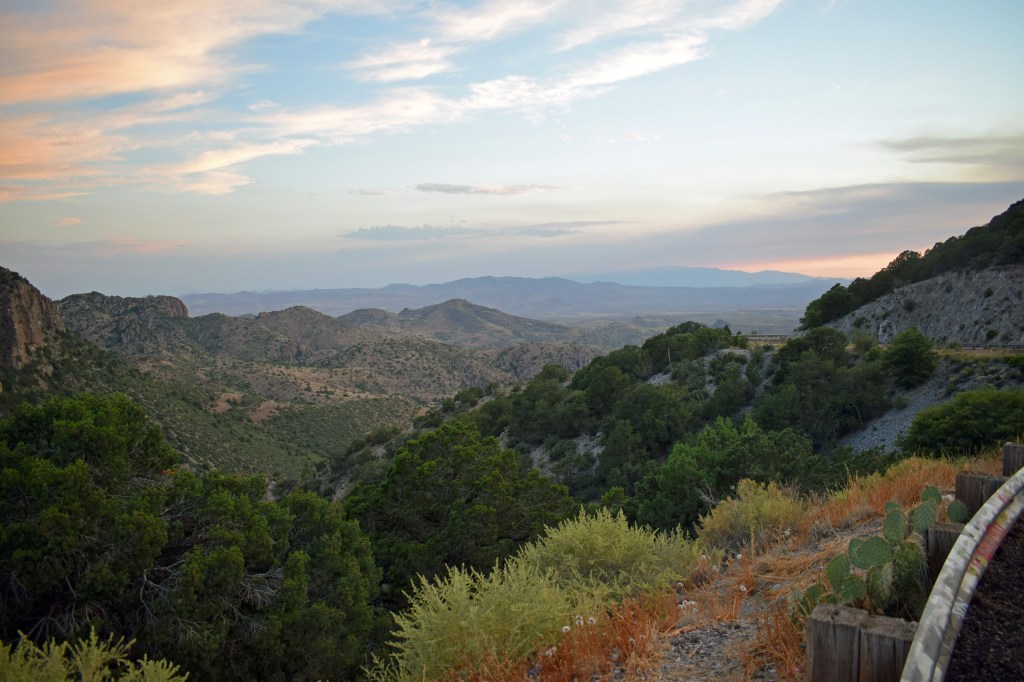
From this vantage, we could see the rising lights of Morenci, the looming mass of Mt. Graham and, behind that, a long brown stain that must have been from the Bighorn Fire in the mountains above Tucson. A tragic sign of the times.
