Before the advent of air conditioning, there wasn’t much that us desert dwellers could do to escape the relentless temperatures of July and August. (Contrary to cliché, it isn’t exactly a dry heat.) The time-honored strategy has been to pack the wagon and head for the nearest mountain. Those with means and a little luck might even get to spend some time amid the pines above the Mogollon Rim.
I recently got an unexpected invitation to share a condo for a few days in Pinetop. So I shook off my summer lethargy, adjusted the sprinkler system, called the dogsitter, and headed off on the diagonal route across the state, AC and stereo blasting.
Beelines & charred remains
In honor of the contemporary wisdom that life is about the journey and not the destination, I’d like to pay a quick homage to the stretch of Beeline Highway between Mesa and Payson that accommodates the migration of Phoenicians up onto the plateau – that outdoor playground in winter and in summer. In the 30 years I’ve lived in Arizona, I’ve somehow always missed that corridor, snaking through essentially untouched saguaro forests and layered ranges in all directions – an unsung finger of the Sonoran Desert.
Beyond Payson, the route is equally stunning – a recently improved four-lane that climbs from the second to the third story of the state, offering expansive views of the juniper and piñon that carpets the rolling mountains to the south, until it finally rises into dense pine forest.

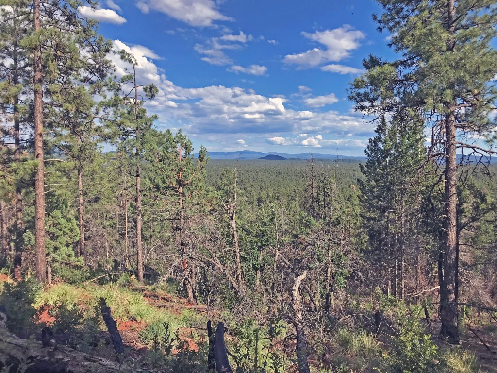
At this altitude, the sky has a completely different look: the gray summer haze is gone, and substantial clouds, some with dark underbellies, sit bold against a vivid blue background. Moving east, the developments of vacation homes grow larger, more frequent, more opulent.
Around Heber, the landscape breaks up a bit, pine forest blanketing the hills, open meadows filling the depressions between. On both sides of the highway, vast stretches are studded with charred stumps and scrawny saplings trying to make a comeback after the devastating Rodeo-Chediski Fire, which within a month in 2002 burned about half a million acres and destroyed more than 400 homes. It was the worst fire in Arizona history up to that point, though it was surpassed a decade later by the Wallow Fire farther east; and, even today, for miles at a stretch a stubble of dead trees crowns the hills, a spectral reminder of what had been.

Family friendly
There’s a little bit of something for everyone year-round along the Show Low-Pinetop-Lakeside strip, slung as it is between a national forest on one side and a couple of Indian reservations on the other. Among the options: hunting, fishing, boating, mountain biking, hiking, skiing, sledding, off-roading, horseback riding, wildlife viewing, not to mention more domesticated entertainments like picnicking, tennis, mini-golf, multiplex movies and, the perennial favorite for childfree adults, bar surfing. The kids, of course, have their smartphones.
One of our late-afternoon diversions was a round of Frisbee golf at the course down by the Nature Center, its volcanic boulders gathered into scattered hillocks. The camaraderie was first rate, the level of play perhaps less so. The course itself seemed to be eked out of marginally desirable real estate, the main obstacles being muddy drainage ditches.
On another day, we took a leisurely afternoon hike along the trail system local to the condo. The four-mile loop known as the Country Club Trail is mostly flat but does feature an optional detour called the Pat Mullen Spur, which switchbacks up a 400-foot bump overlooking the patchwork of hills and meadows to the north.
On the weekends especially, a steady stream of families and outdoorsy couples comes and goes from its parking area – an intermittent single-file line visible here and there for a quarter mile through the trees. In fact the trails outlying the residential developments have been purged of much of their wildness, having been cleared of underbrush and even, it seems, of any accumulated pine needles. I had to wonder, where do they put all that organic matter?
The high road
During our sojourn in the pines, the high point – quite literally – was our hike in the Mt. Baldy Wilderness, a few miles south of the Sunrise Ski Resort in the heart of the White Mountains. The road out that way – Arizona 260 toward Springerville and Greer – forks off at the Hon Dah Casino and follows the northern edge of the Fort Apache Indian Reservation. (The winter sports complex is owned and operated by the Native Americans, unlike the other regional ski area of choice, the Arizona Snowbowl, which the tribes sued all the way to the U.S. Supreme Court in an attempt to stop the pumping of Flagstaff sewage up to the San Francisco Peaks to make snow.)

As a whole, the White Mountain Apaches appear to be a thriving and hospitable people. Historically, being among farthest west and among the last to come under federal authority, they were given more freedom of self-governance than most – in spite of, or perhaps because of, the ferocity of their struggles for control of ancestral lands. In any case, they have ended up with a beautiful corner of the earth from which to contemplate Creation.
In terms of elevation, the record holders in Arizona are around the rim of the shattered volcano near Flagstaff known as the San Francisco Peaks, rising to 12,600 feet. In second place are the White Mountains, and Baldy Peak is their high point, at 11,400. The upper reaches of Baldy are open only to tribal members, but two public trails – an “east” and a “west” – carry hikers most of the way to those sacred grounds.
Hoodoo you think?
Many of the parking areas for the Pinetop-area trailheads are intentionally small, in an effort to limit the impact and enhance the hiking experience. When we arrived, the lot for Trail 95 was full, but a weary couple were just coming out of the woods, so we got their spot. In fact, since we were getting started in mid-afternoon, we passed a couple of other groups coming out, including a young family with five kids, the smallest two riding piggyback, having reached their limit. I said I wanted a ride, too, but the sweating parents didn’t see the humor.

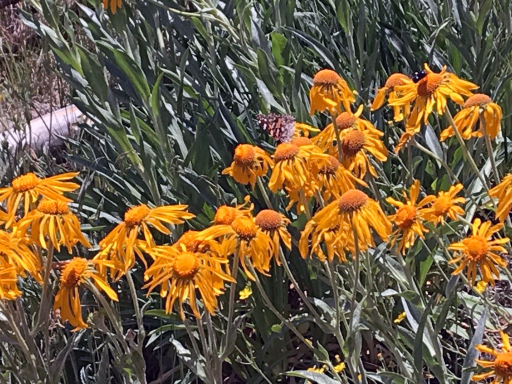
For the first mile of the hike, the trail skirts a chain of meadows, bisected by gurgling creeks – the headwaters of the Little Colorado, whose eventual confluence with the Colorado marks the beginning the Grand Canyon. In this area, we saw at least a dozen species of wildflowers. Most of them were tiny and delicate, indistinguishable from more than a few yards away, but as we continued we realized that the meadows were filled with them.
For the next mile, the trail gradually climbed, undulating beneath the forest canopy. As guests in this wilderness of fir and spruce, we tried to recall what we were supposed to do if we stumbled upon a black bear or a mountain lion.
At one point, when we stopped to rest, a pungent scent of pine filled our sinuses. I noticed that a huge dead tree had recently toppled across the trail nearby, snapping off a smaller live one and exposing its bright orange heartwood. The circle of life.
At about that point on the trail, we began to see the exposed sandstone boulders we were expecting. A little further on, giant hoodoos of the same material towered above the trail. Had I been a prehistoric native of the area, I certainly would have believed that these were sentient beings in repose, passing silent judgement upon their puny visitors. No wonder this mountain was sacred.
Holding the high ground
The trail zigged to the right along the base of an impressive bank of monoliths, then zagged left up the slope behind them. From this ridge, we could see some distance to the north through the trees. Then the trail threaded the needle between twin columns, and we emerged into the open onto a bare rock ledge overlooking a panorama of hilltops and valleys to a distance of at least 50 miles.

Out on the farthest point above the cliff, we spotted a handful of stoners, quietly huddled among the boulders. We sidled out to the edge for the obligatory selfies, reminding each other that we had many productive years ahead of us, not to be cut short by a random misstep.
We considered following the trail where it led out of sight around the highest rock jumble to see if we could get a similar view in the other direction, but we began to hear distant thunder and noted that the sunny day had suddenly turned overcast. A bank of dark clouds stretched the entire breadth of the sky to the north, at its midpoint the gray blur of a rainstorm. This would be an idea place for a lightning strike, so we started back, the first drops stirring up dust around us.

Gimme shelter
The hike back was much easier going, but we were pretty tired and just couldn’t bring ourselves to jog. At halfway down the rain was steady, and with a mile to go we were soaked and shivering. At one point, we noticed tiny specks of hail bouncing off the pine needles.
We were still at least half a mile from the end when we passed a young couple meandering up the trail, entirely unprepared for hiking and oblivious to the rain. They were laughing and chatting and tugging at the undergrowth, pelting each other with flower petals. I speculated that they’d end up in the shelter of an overhang, huddling contentedly for warmth. In support of this theory, even after we had stowed our wet gear in the car and pulled out onto the blacktop, they were nowhere to be seen on the trail.

Windshield wipers pounding, defogger blasting, we stayed well under the 45-mile-per-hour limit as we headed toward the line of blue sky in the distance. Since I’d had to shed my soaking clothes, I thought it best to avoid getting pulled over by the tribal police.
