In this era of extreme weather events, we can be happy for anything that looks normal. With this year’s wetter-that-average winter, Arizona saw some exceptional wildflower blooms and even snow at lower elevations.
Make no mistake, though: the entire state is in extreme-drought status over a 20-year period, with the first half of the present decade rated by some measures as the driest in 700 years. So seeing a few good cold fronts back to back makes me nostalgic for the last time we had a nice wet spring, back in 2005.
Penetrating the wall
By February of that special year, the wildflowers had gone berserk, so we resolved to get out to where they were likely the most spectacular.

It happens that one of the most remote, undeveloped areas in the continental U.S. lies between Yuma and Phoenix – perhaps 6,000 square miles bordered by I-10 and I-8 on the north and south, and by the Gila and Colorado rivers on the east and west. (And that’s not counting what’s south of I-8.)
The western half of that huge tract is mostly taken up by Yuma Proving Ground, which is off limits to the public, and the Kofa Wildlife Refuge. We had made several forays into the west side of the Kofas facing U.S. 95, but we always wondered what was behind the massive rock rampart that tapers down on its way north toward Quartzsite.
King of Arizona
We staked out a long weekend for a couple of nights’ camping and, after driving an hour out of town in our rented SUV (we were currently between Jeeps), we turned east onto the graded road that traverses the vast drainage of King Valley on its way to Wellton.
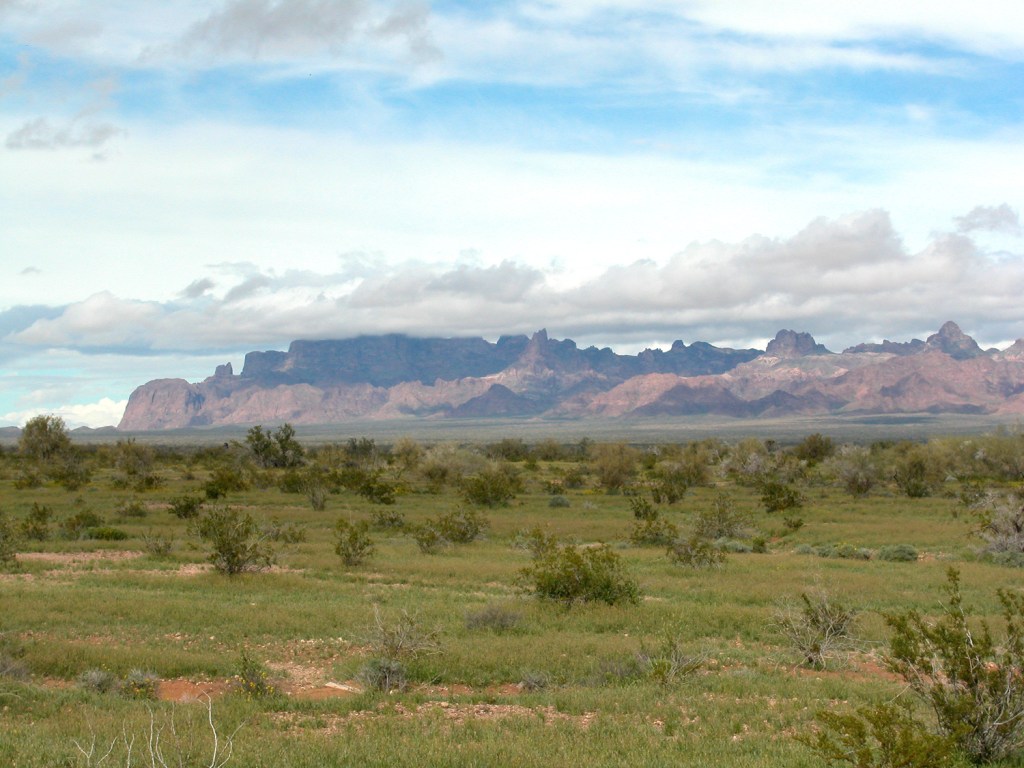
To our right stretched the ragged silhouette of the Castle Dome range. To our left, the huddled mass of the Kofas was in some places golden in the slanting winter sunlight, in other places black under what seemed to be a custom-fit cloud blanket.
We turned north onto a side road until we came to the King of Arizona mine (acronym, KOFA), nestled among the foothills of the range. There was no sign of life, but the cluster of mostly well-maintained buildings and a couple of parked pickups indicated a continued human presence, possibly for purpose of keeping the permit active.
Framed by the canyon that apparently hosted the mining activity was the imposing red face of Kofa Butte, which we would approach from the opposite side the following day.

When it rains
From the mine, the track becomes truly primitive, jogging and dipping through deep washes and finally among the granite outcroppings of Engesser Pass. Now within the inner basin of the range, we turned to the left up a major wash that led directly toward the distinctive wedge of Polaris Mountain.
In this remote pocket of wilderness, far from the meddling of men, there are few non-native plant species, and we saw a few for the first time, among them what looked like a paloverde with unearthly gray bark. All around us were signs of the recent rains – crevices with standing water, soggy patches of sand and, most striking, vast carpets of varicolored wildflowers.

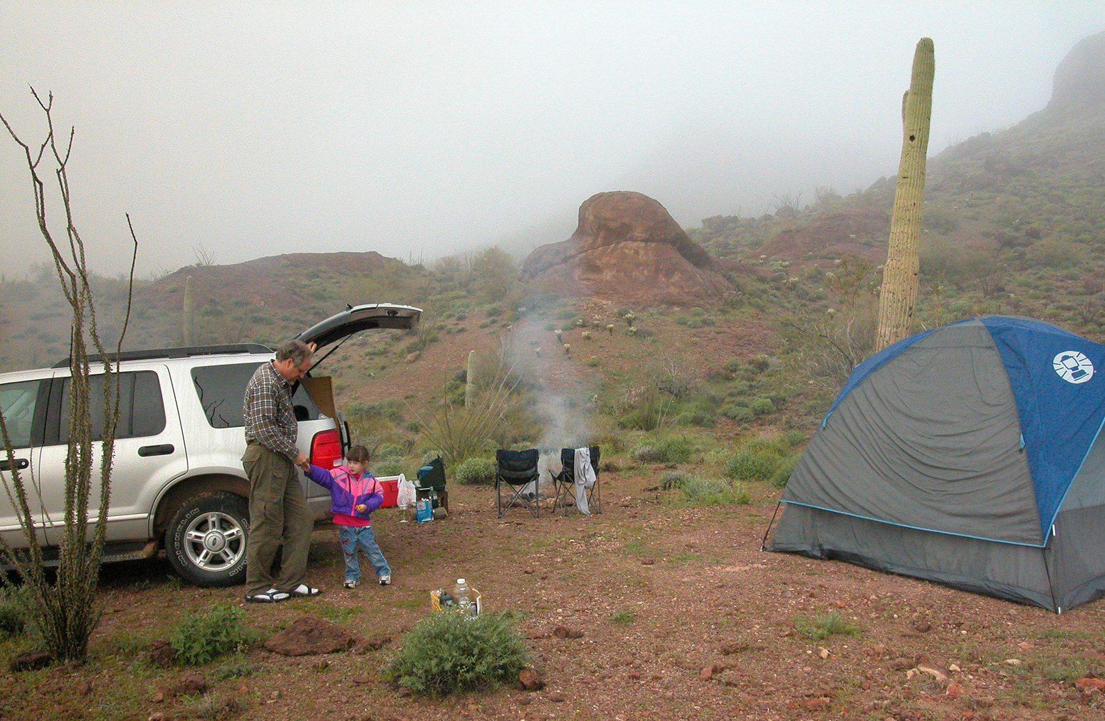
We stopped for the night at what appeared to be the end of the road. I was stiff from hours of driving, so I slogged up the loose gravel of a nearby hill while dinner simmered on the cook stove.
Abruptly I realized the light was almost gone, and I looked up to see a heavy cloud sliding in from the northwest, lightening popping within its depths. In my haste to get back down the hill, my feet slipped from under me on the unstable slope. The unaccountably sharp pain on my shinbone told me I had caught a rock in just the wrong way.
The leg wasn’t broken, because I could still hobble on it back to camp, but I had an angry gash along the bone. We had just enough time before the storm hit to regret setting the tent on top of a bare hillock, and we spent the next hour huddled in terror while the cold wind tore at the lightweight tent, besieged by blinding flashes and their instantaneous deafening reports.
Lost in the fog
In the morning, our little hollow among the hills was enveloped in a dense blanket of fog. In the perfect silence, we might as well have been buried in cotton.
The fog only began to rise after we had finished eating a leisurely breakfast and packing all the gear – neither activity getting much help from me with my throbbing shin. As soon as we could see beyond the nearest rises, we set out toward the elegant opening among the hills, where we knew we would find Yaqui Tanks.
After the heavy rain, the series of catchments in the bedrock were all flushed clean and brimming with pristine water. Crisscrossing tracks in the soggy sand and some fresh scat told us that a variety of wildlife already had been down for a refresher.

To the south, sliding in and out of sight as we walked along the canyon walls, was the backside of Kofa Butte. Though we had covered at least 20 miles on the rugged Jeep track, we were only a mile or two from KOFA mine as the raven flies.
Heart of the refuge
To get to Manganese Road, which leads into the heart of the range, we had to backtrack out of this southern pocket until we arrived again at the open plain along Hoodoo Wash.
Into the distance, the brilliant blue of the sky was broken by drifting tufts of cottony clouds, and the entire desert was a green sea of lush groundcover, with broad patches of blue lupine, yellow daisies and orange poppies. Many of the cacti – saguaros, cholla, barrels, prickly pear – also were adorned with their short-lived blooms.
The sandy road winds among an increasingly impressive string of hoodoos, arches and cliffs. At one point the track crossed a wash just below another set of shallow catchments named Raven Tanks, so we stopped for a stretch and our ritual snack of crackers, sardines, apple slices and gourmet cheese.
We spent a magical afternoon stopping constantly to gape at the undulating ocean of poppies till the road finally ended at a tee. To our right, the broad drainage would be the long, slow way out the next day. To the left, the wash stretched only a short way before losing itself in a network of box canyons.

We couldn’t even find the old trail, long since out of service, that leads up slope of the mountain. This was the direct way out by far – over the saddle, into Queen’s Canyon and out to the highway past Palm Canyon – but even in its day it would have challenged the sturdiest of vehicles. Reportedly, descendants of pioneer royalty still are allowed to sojourn at the cabin built by a certain Jack Wilbanks, if they’re willing to go the trouble to get up there.
Close call
I’ve had a lot of close calls in 30 years of blundering about in the Southwest wilderness, but what we did the next morning must be in the top 10.
Just past the main intersection is a narrow neck of the wash where the intermittent torrents of rainwater have piled the smooth river rocks into a loose jumble. I was halfway into the pile before I realized I wasn’t going to make it through at that speed and that angle. I had to spend an hour clearing away rocks – my injured leg throbbing the whole time – until I finally could back up and try again.
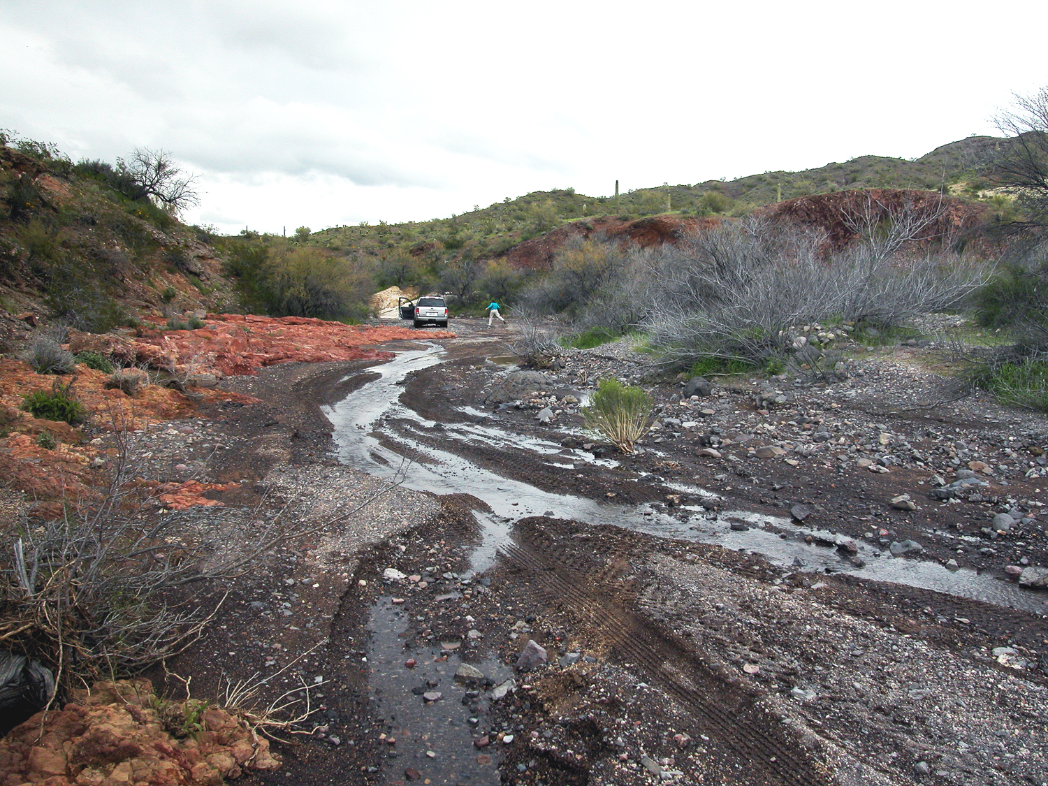
There was exactly one maneuver that was going carry the vehicle through that spot. Any deviation would have sunk it to the chassis, and we never would have been able to extract it without help.
In the back of my mind must have been the memory of 10 years earlier, concerning a colleague of mine. In the exuberance of fresh romance, he had piled his new girlfriend and her four kids into a Suburban and headed for the hills. When he didn’t show up to work on Monday, the search helicopters spread out and found them huddled around the stranded vehicle. I would bet even money that this was the exact same spot.
That was before cell phones, but even on our trip there was no possibility of any connectivity that far off the beaten path. Possibly inspired by the earlier incident, we had made sure that a couple of friends and relatives knew our intended route. By the grace of the gods it wasn’t necessary.
The way back
With the exuberance of reprieved prisoners, we whooped it up, careering along that widening wash to the lively soundtrack of a Steve Miller compilation. In many places, we had to avoid rivulets of water draining in from the rain-soaked hills.
Our lunch spot was at a hill pocked with natural caves, where we spent too long photographing the pair of hawks riding the air currents above the cliff on the other side of the big wash.

Finally, we reached the open plain, where we came to a stone cabin sitting alone at the intersection of roads. It was boarded up tight although it was in no danger that day of a break-in, its only visitor a massive raven hopping about nearby – apparently so well fed she couldn’t get airborne, even with the annoying proximity of humans.
As we floated along the blacktop rollercoaster of Hwy 95, the top of the range was once again lost in clouds. We had survived another odyssey, but we’d probably be on the car-rental blacklist after this one.
