We finally decided we could devote our winter break to driving down the Baja Peninsula. It would be a 15-day adventure and a 2,600-mile round trip from Yuma down to Cabo San Lucas and back.
My wife, Lori, had made the trip with a girlfriend a dozen years earlier and thought it was high time I had the experience, too. And, at 5 years old, our daughter Mary was old enough to remember it.
We spent a couple of weeks lining up what we thought were the essentials – Mexican auto insurance (essential indeed), a Mexican tourist card (which we never ended up using for anything) and a temporary international plan for our Sprint service (which never actually worked).
On this sunny Christmas Eve we stuffed the bullet-shaped carrier on top of our black Jeep and headed west on I-8. When we showed little Mary the map of our destination, she said, “It must be God’s finger!”
Wine country
At the Campo exit high among the Laguna Mountains in California, we exited into the village of Manzanita, where the quaint Mountain Top Store and its friendly proprietors take you back several decades. The windy, boulder-lined road through Campo to Tecate – laborious but stunning – I was pretty sure I recognized from an old Roger Corman racing movie.
Crossing from the U.S. into Mexico is always one of the more dramatic contrasts you can find – dogs barking at you from the rooftops, an improvisational approach to driving, half-finished cinderblock constructions. We must have spent an hour shopping and people-watching on the bustling, beautiful city square of Tecate, home of the regionally popular beer.
The trip down Hwy 3 to Ensenada on the west coast has a different libation to offer – wine. This route through the vineyards seems to have taken its cue from Napa Valley in developing as a tourist destination. Many of the establishments have recently built a motel on the grounds for those really serious about tasting the variety of wares.

At a town called Francisco Zarco, we hunted down the bakery, run by a family of Russian immigrants, that was mentioned in our guidebook, where we stocked up on cheese and sweet bread.
The coastal highway
As with so many places on the West Coast, the drop down from the hills to the ocean is breathtaking. But the coastal road itself, although it’s improved a lot in recent years, is crowded and frustrating. In Ensenada we made a loop down along the cheerful waterfront, but back on the truck route we crept through the sprawling city among darting taxis and loud, listing gravel trucks.
The highway from Ensenada to Colonet is significantly inland and no doubt beautiful. But it was approaching nightfall, and I had to concentrate on the traffic and the narrow roadway.
After Colonet we regretfully passed the turnoff into the Sierra San Pedro National Park. At 10,000 feet, the Picacho del Diablo would be covered in snow; that trip would have to wait for a different time of year.
From there, I don’t think we missed much in the dark. The road is flat and straight through a long string of identical, dusty agricultural villages, each with its set of speed humps. All the Pemex stations appear to be new, created in the image of the American Circle K, with a mini-mart inside and clean bathrooms – but still with the traditional full-serve attendant at the gas pumps.
Heaven
When we finally reached San Quintin, I suddenly realized I’d been driving for about 12 hours through some pretty tough conditions. We watched for a motel, but the only ones listed in the book were right on the dusty truck route.

In one of our luckier decisions, we pushed on and left the highway for the dirt roads, searching several villages for the turnoff out to Cielito Lindo – “Pretty Little Sky,” or “Heaven” if you prefer – a charming hotel-restaurant right on the Santa Maria Bay.
We weren’t sure at first if the place was open. It was pretty dark, and the three or four cars might just belong to a handful of winter caretakers. But there actually was music coming from the restaurant.
At the bar were a handful of retirees from a nearby RV park, expatriates maybe, singing along to the ‘60s oldies emanating from portable radio. We occupied the table next to the fireplace and feasted by candlelight on ceviche, shrimp and a mountain of cracked crabs in mild red chili and oil, washing it all down with Negro Modelo.
We were one of only two groups staying overnight, the other being some schoolteachers from central California who convened at this spot every year. Exhausted, we crossed the vast courtyard, whose fountain and walkways with their intricate inlaid stones we would be able to appreciate only in daylight the next morning.
Our room was unheated but spacious. On the dresser top, we laid out a few presents we had brought along to open in the morning, and then dove under the comforters.
That was the first day.
A hard road
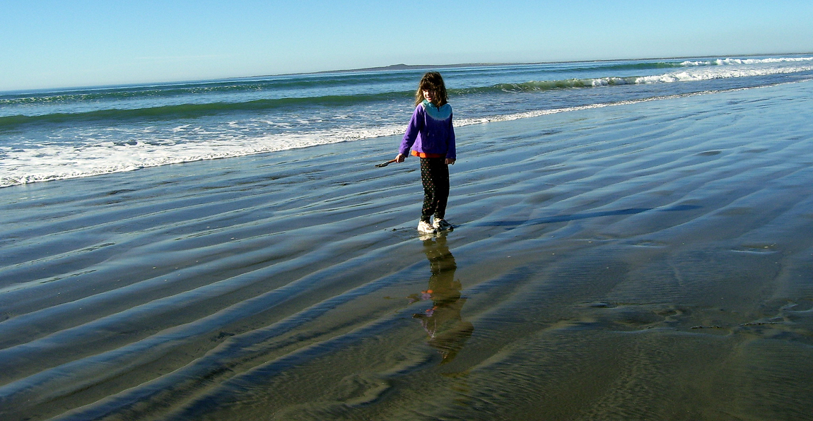
On Christmas morning, before leaving Cielito Lindo we took a stroll on the beach. From atop the sand dunes could be seen the seven charming little volcanic islands that protect the Santa Maria Bay.
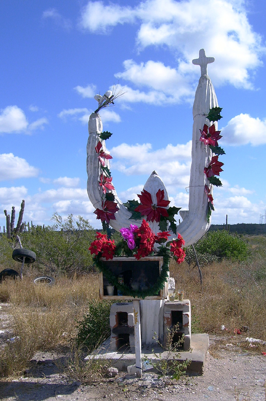
Mexican Hwy 1 follows the ocean from San Quintin to El Rosario, then climbs to a plateau and heads inland across the desert. From here on, this solitary paved artery has a consistent quality: that is, the roadway is a narrow two-lane with absolutely no shoulder; and it’s built up, with ditches about six feet deep on both sides. To ensure the drivers’ vigilance, the entire journey is punctuated with colorful roadside shrines for the travelers who have met their end along the dangerous route.
Certainly there is no margin for error, and it was constantly a marvel to us that two semis – or two RVs – could pass each other at all. What was even more amazing were the die-hard cyclists, loaded down for a weeks-long trip, creeping across the barren landscape just inches from the whizzing traffic.
On this particular day we passed a U.S. family with innovative equipment: the mother was packing most of the gear on her bicycle, and the father had not one but two children, each on a separate seat and wheel attached to his bike in a series, like little train cars. No matter where they were heading, they had a long way to go, and we said a prayer for them as we passed.
Crossing over

At about the middle of the peninsula, one passes through a desert preserve, actually part of the Sonoran Desert that includes southern Arizona. It features a huge variety of exotic cacti such as the giant cordon, a relative of the saguaro, and a tapered, spiny tower called a “boojum” tree in reference to a Lewis Carroll poem.
The highway follows this lush desert for some miles and finally reaches the turnoff over to Bahia de Los Angeles on the eastern coast. The view from higher ground down to the Gulf of California is especially spectacular at this point. The Mexican mainland is not visible, but a huge island, The Guardian, protects the gentle curve of this bay. The contrast of blues and browns is hypnotic.
Our plan was to camp half the time on this trip, so we located an establishment, run as usual by Americans, at the far end of the beach. We were directed to one of the thatch shelters (palapas) facing the water and grilled our food over the barbeque pit. Predictably, the stars that night were breathtaking.
***
This story previously appeared in the January 18, 2009 edition of The Sun (Yuma, Az)
