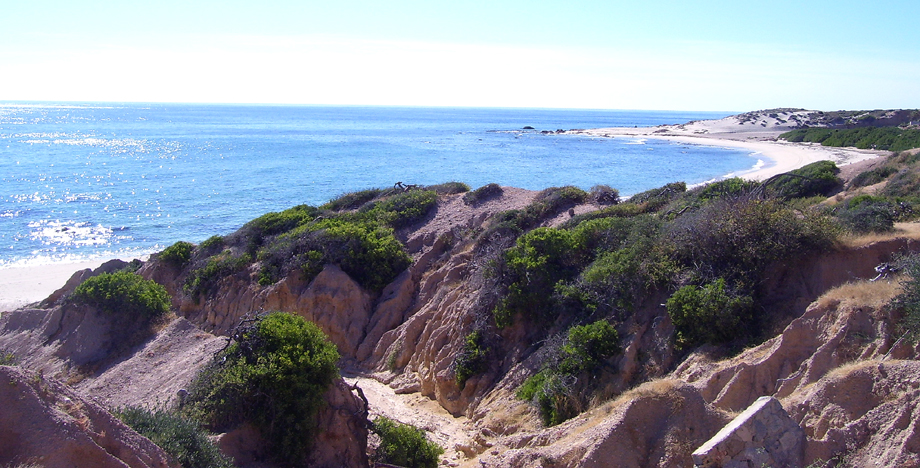
At Cabo Pulmo we were just inside the Tropic of Cancer. We woke up on New Year’s Day in our thatched cottage and headed south along the sandy road that follows the eastern shore toward the tip of the peninsula, easily one of the most beautiful stretches on the Baja.

Within a few miles we passed the cove we had visited the day before. We had tried to kayak out to see the colony of sea lions around the point, but as soon as we had passed the shelter of the rocks the wind from the open sea stopped us cold. We had spent the day instead snorkeling among the amazing variety of tropical fish. I had to dive several times to admire one particular moray that had looped itself into the porous coral.
The fingertip
The coastal road alternately dips down to beaches like this one and rises back up to gentle grassy hills with spectacular views of the sparkling sea. At one point we got out the binoculars and watched a gray whale and her calf slowly making their way north from the ocean into the Gulf of California.
Elaborate homes are widely spaced all along this stretch, owned mostly by wealthy Californians, we guessed. Many of them are new or under construction, and we speculated on how long it would take for this area to be fully developed, with a paved road and dense condominiums.
Finally, we had to cut away from the coast. It took a bit of trial and error to find our way on the back roads into San José del Cabo, probably the lushest and most genteel city on the peninsula.
We ate a hearty lunch in a second-story restaurant overlooking the shaded Boulevard Mujeres. At the cathedral a block away, a wedding was just ending, and the guests were spilling into the beautiful plaza, where a life-size nativity was set up.
Hwy 1 between San José and Cabo San Lucas is the only significant stretch of four-lane we would see on this trip of 2,400 miles. Indeed, The Corridor, as it is called, could easily be somewhere in Southern California, with its condos and golf courses and gated communities.
We pulled over for a picture of the offshore island arches – the signature sight of the Baja – and made a quick loop around the downtown harbor area for the record, then we pushed on up the west coast.
We were looking for a campground south of Todo Santos where Lori had stayed a couple of years before. To find it, though, we had to explore a few rural neighborhoods dotted with vacation bungalows.
It turned out that the campground had long since closed and had been taken over by bands of surfers, their VW vans scattered among the dunes. The ones with seniority actually occupied the deserted administration building, their colorful boards leaning against the crumbling stucco and their laundry hanging from the windowsills.
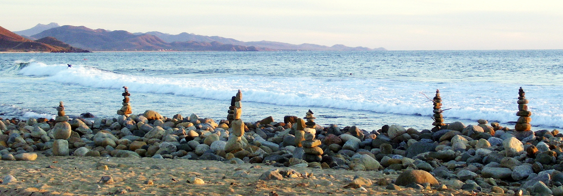
Swimming was out of the question because only rocks lay beneath the surf. One area, where the visitors had made towers of these smooth stones with the patience of eternal youth, looked like a pagan shrine.
This is evidently a premier surfing spot. All evening and then again in the morning we watched the thrilling acrobatic displays.
Backtracking
In the artisan community of Todo Santos, we ate crepes at a New Age café that might have been in downtown Sedona or Taos. Then we browsed the galleries, with their paintings and displays of silver jewelry.
At one folk-art shop we made significant additions to our collection of masks, though we had no room for them in the Jeep. We even bumped into a couple of our buddies from the beach at Mulejé.
The rest of the day was spent on the long drive back to Loreto on the east coast. Just as we made the mountain pass overlooking the Gulf of California, a full moon was coming up over the water. Lodgings that night in Loreto were a U.S.-style motel, with a courtyard – and an unheated pool.
In the morning, we set out for the San Javier Mission up in the mountains. The initial stretch inland was closed because work was just getting underway to pave this road up to the mission, so we had to follow the nearby riverbed.
The road into the mountains is only one lane, so we chewed our nails to the nub on the blind switchbacks. At intervals, roadside shrines mark the sheer drop-offs, but the views out to the Gulf are to die for.
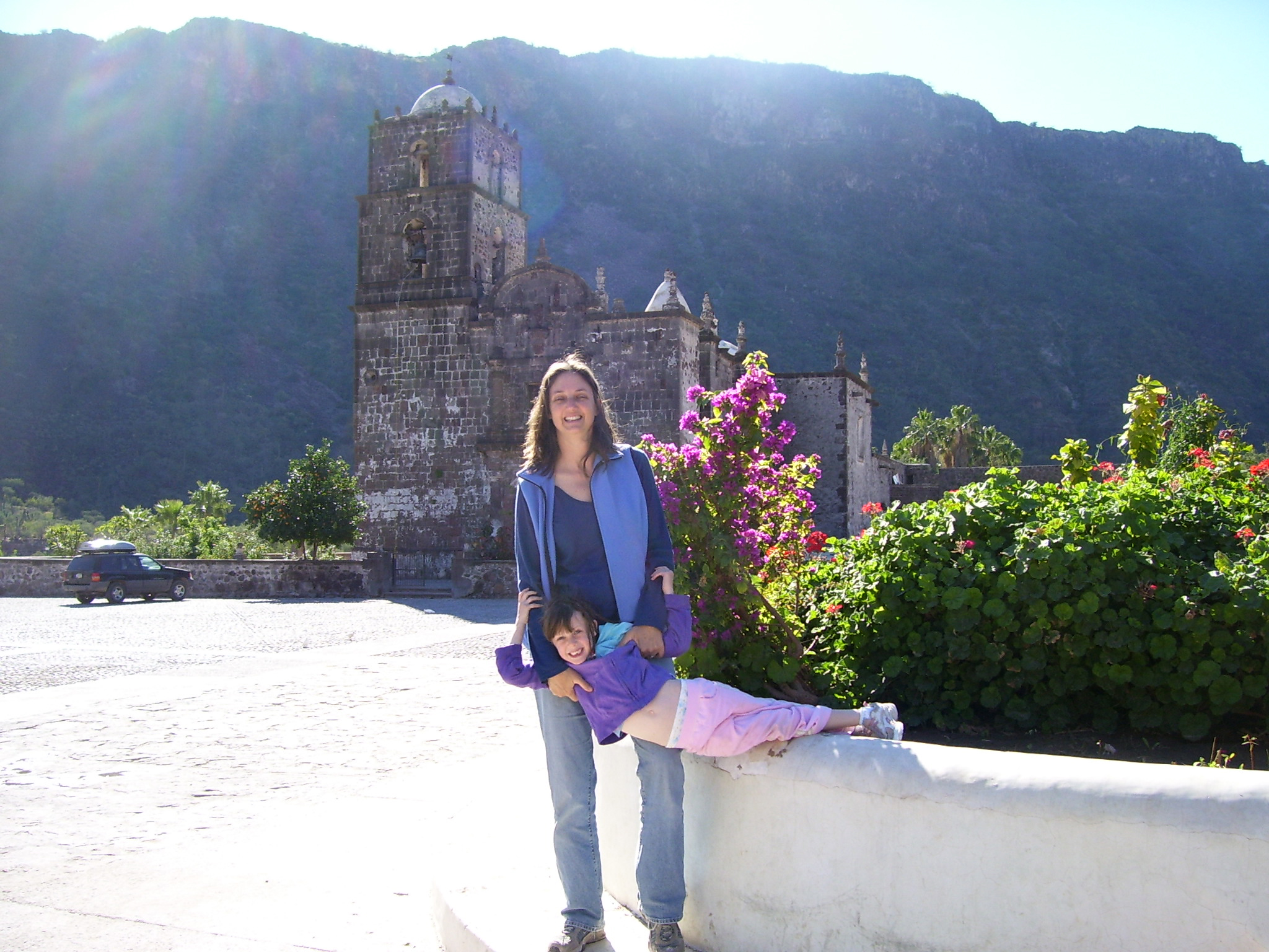
The tortuous drive is easily justified by the mission’s stunning setting – a lush miniature valley. The building has obviously enjoyed a recent facelift, and the gilded altar is the largest and most elaborate of those we saw.
The main street through the village has been freshly surfaced with cobblestone. Evidently the residents are anticipating an upturn in the tourist industry once the road from the coast is finished.
By evening we made it all the way back to San Ignacio, in the heart of the peninsula. We caught the museum staff just as they were leaving and, as required, arranged for our trip out to the remote cave art sites in the San Francisco Mountains the next day.
Our room that night was at a local family’s house right on the plaza. We ate dinner with them and then spent a freezing night in a windowless add-on out back.
An ancient record
We got up before it was light in order to make our rendezvous with the guide up in the hills. We had to backtrack on the highway a few miles to the east and then turn north on a jeep track.
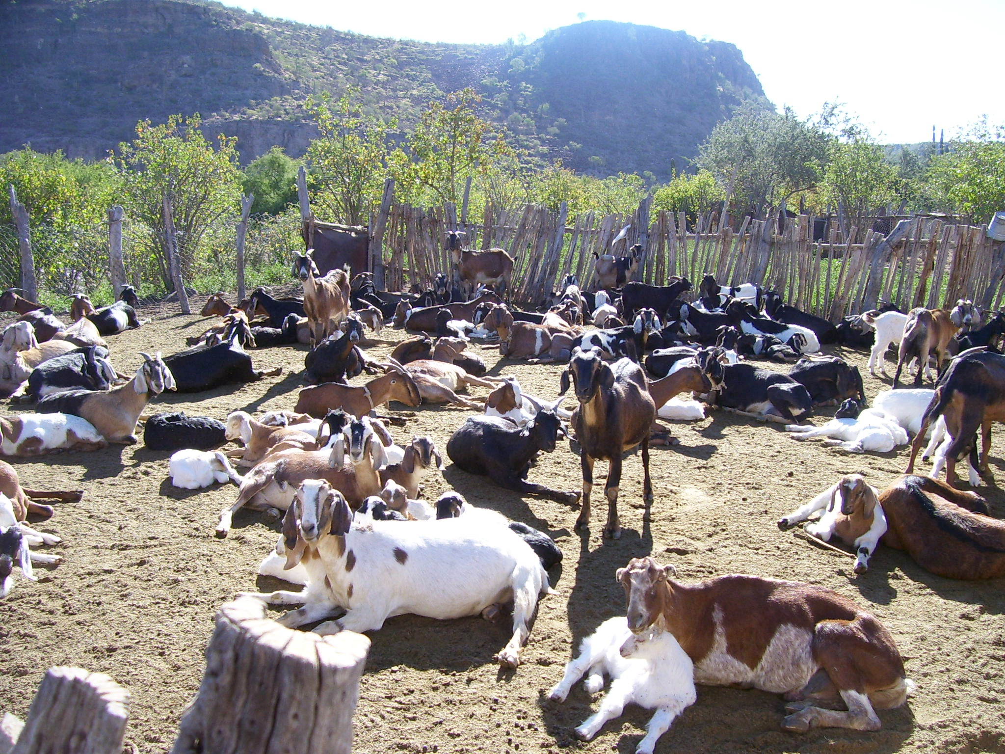
At an optimum pace that wouldn’t be too hard on the vehicle, the trip took about two hours. The vegetation was stunning, though, interrupted only by an occasional dusty homestead with goat pens and a shack or two.
At last we came to a family house at the end of the road. The veteran guide already had taken a small group up the trail, so we were assigned to his son, Martin. Martin (and, we would discover, his dad) seemed to be bred for this work of loping back and forth across the desert terrain; both of them were beanpole thin, with stilt-like legs.

We got the feeling that Martin had trouble regulating his pace for us. Lori and I both have long legs, too, but we also had 5-year-old Mary, and I had to carry her most of the way, which we figured must be about five miles on an increasingly upward slope.
Finally, we came to a brief set of switchbacks, and above us we could see the cave – an overhang, really. Martin let us through the gate in the chain-link fence just as the other party was coming out.

The rock face is completely covered with the red-and-black outlines of various desert animals and of humans about twice life size, and there’s one very clear rendering of a whale. We had first learned about these remarkable drawings about 10 years earlier when we had studied Spanish in Cuernavaca, south of Mexico City. Our art-history lecturer had referred to them reverently as proof of an intelligence in this hemisphere as advanced as anywhere else in the world at the time, several thousand years ago.
The two-tone men, it is said, represent demigods. But we’ll have to rely the findings of the ongoing archeological survey for any interpretation, for the Cochimi Indians, ancestors of these artists, have not survived the European immigration.
One more crossing
That evening when we got in to Guerrero Negro, the transition point between the north and south peninsula, we had another excursion to book. This was the beginning of the whale-watching season, and we wanted to catch one of the early launches out into the bay.
In the morning, we drove out onto the salt flats and finally came to the boathouse at the water’s edge. The wind was blowing so hard, though, that even this sheltered bay was flecked with whitecaps.
About a dozen of us pilgrims had gathered. We were given full-length raincoats and loaded onto two launches, and our helmsmen set off against the waves, spray flying as if we were in a storm.
Quickly it was obvious, though, that the weather was too rough for us to see anything even if we encountered whales, so we turned back. We were told we’d try again if the wind died down. But, after an hour of sipping cocoa on the enclosed porch and peering into the overcast distance, we reluctantly collected our refund and resolved to use this excuse for a future trip down this way.
We drove hard to the north, beyond the turnoffs to San Borja Mission and Bahia de Los Angeles, to Chapala – not a place so much as an intersection – and turned in on the graded road that would take us up the eastern coast toward San Felipe and Mexicali. This was our first experience on the trip with washboard surfaces, and we decided we preferred the undeveloped desert tracks.
In the middle of nowhere we came to Koko’s Corner, pretty much the only outpost along this stretch of the annual Baja 500 cross-country motor race. The proprietor was on hiatus in the States, but we poked around among the various structures and devices – all made out of Pacifico beer cans. Inside was a tiny saloon with undergarments stapled to the walls (we did not contribute our own), and Lori said that the ladies’ outhouse featured a small library of eroticism in Spanish.
It was getting late when we hit the coast at Bahia San Luis Gonzaga, so we provisioned ourselves at the general store and asked about camping out by the beach. We were counseled that we didn’t want one of the palapas in this wind, so we settled for one of the restroom areas in the unfinished café next to the water.
Sure enough, all of the beach houses were boarded up against the weather, and we were alone. We cooked dinner on the porch in the lee of the howling wind and watched the moon rise above the crashing waves.
Heading home
The northeastern coast is considerably more barren than the rest of the peninsula, and it seemed especially so in the cold wind. We did enjoy the view of the desolate offshore islands, one of which looks just like a shrouded corpse – thus the name El Muerto. But the road from Bahia Gonzaga to Puertocitos, where the pavement finally resumes, is easily the worst I’ve ever experienced.
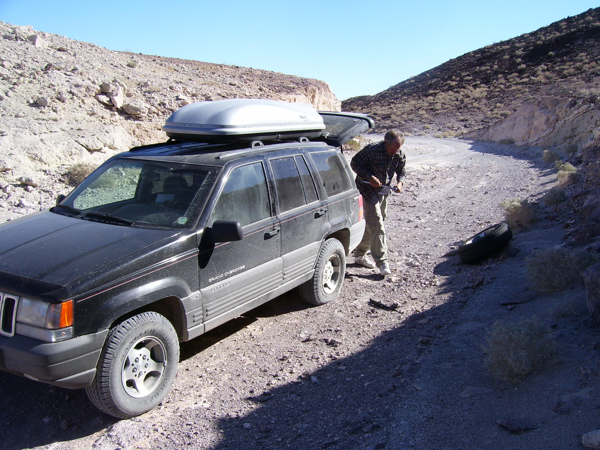
To make more than five miles an hour, one has to ignore the consequences to one’s vehicle. When I stopped to take a break from the physical work of driving, I realized that I’d punctured a tire on one of the sharp rocks.
We wanted to try out the hot springs at Puertocitos, but they sit among the rocks at the water’s edge and can’t be accessed when the tide is in, so we just ate lunch in the restaurant, happy to be sitting still.
The paved road north is smooth and new but built like a roller coaster, so we were a little seasick when we arrived at San Felipe. I hadn’t been down there in several years and was astonished at the new condominium developments, especially south of town.

The downtown Malecón, where the shrimp boats were beached, is still pretty much the same, and we observed our ritual of visiting several seafood stands. We also loaded the Jeep the rest of the way with Mexican handcrafts.
We had intended to spend our last night here, but now we were out of pesos. Besides, we were weary and decided we wanted to spend one whole day at home before we went back to work, so we started off on the four-hour drive to Yuma on that cold, clear night.
At the Mexican army checkpoint we thought the glum soldiers would want to search us from top to bottom, out of boredom. But when they found out we could actually wish them a happy Three Kings Day in Spanish, suddenly they appeared as what they really were – a group of freezing kids who were just happy for some friendly talk.
Approaching Mexicali, we calculated that we wouldn’t make the midnight closing time at the border crossing east of town, so we headed into the city center. (I had forgotten how vast that urban area is.) Unexpectedly, there was no line at the border.
We figured we were perfect candidates for secondary inspection – our dusty Jeep stuffed to the ceiling with disordered gear and a five-year-old passed out akimbo in the back seat. But the customs agent took one look at us, laughed, and waved us through.
It had been quite an adventure, but we were inexpressibly relieved to be driving on the Interstate, with its four lanes and 10-foot-wide shoulders.
***
This story previously appeared in the February 1, 2009 edition of The Sun (Yuma, Az)
